Recently I have returned from Southern Utah from what was an exceptional and diverse 2-week adventure. It consisted of a four-day national park exploration with my dad, followed by a memorable week of Boy Scout camp located on the top of a high mountain at around 9,500 feet of elevation.
The American West is truly remarkable and, having never seen it for myself before, I was thoroughly shocked with the outstanding beauty of most places I visited! I’d never seen a place before where eroded red rock formations blended with high desert and conifer forest to form almost otherworldly scenery.
I wasn’t as focused on wildlife this trip, though after seeing quite a number of wild animals as I hiked through the national parks, I managed to amass 7 species of mammals (all lifers), and 21 species of birds (including 12 lifers). For this blog post, I’ll focus on the national park exploration I embarked upon with my dad all the way up to my departure for Boy Scout camp.

My dad and I departed Shelter Island, New York to catch our bus to the airport before the afternoon on the 22nd of June. We meandered over to Bridgehampton to kill time before the bus to our airport hotel at JFK arrived. After a nearly 3-hour, excruciatingly uncomfortable ride to the hotel, and some midnight Chinese food, we both hit the sack, ready for our flight to Las Vegas in the morning.
The flight was actually pretty enjoyable and so was the Vegas airport (although the copious amount of slot machines throughout the terminal was off-putting). We got our rental car and continued to spend the next hour or so seeing some of the sights of Vegas. My dad, who spend some summers out here when he was my age with his father, showed me a few popular spots along The Strip. We ate a delicious lunch at Momofuko, a Chinese fusion restaurant run by a famous TV chef before hitting the road again.
The next leg of our journey consisted of driving two hours through the desolate and quite alien-looking Mojave Desert. Having never been to a desert before, I was consumed by the aridity and colors of the landscape as we sped through it at 90 miles per hour. We arrived in St. George, Utah, at around 5pm and proceeded to visit our friends for the next few hours. We were on the road once again at around 9pm and arrived at our inn near Zion National Park late that night, ready for a great two days in the park.

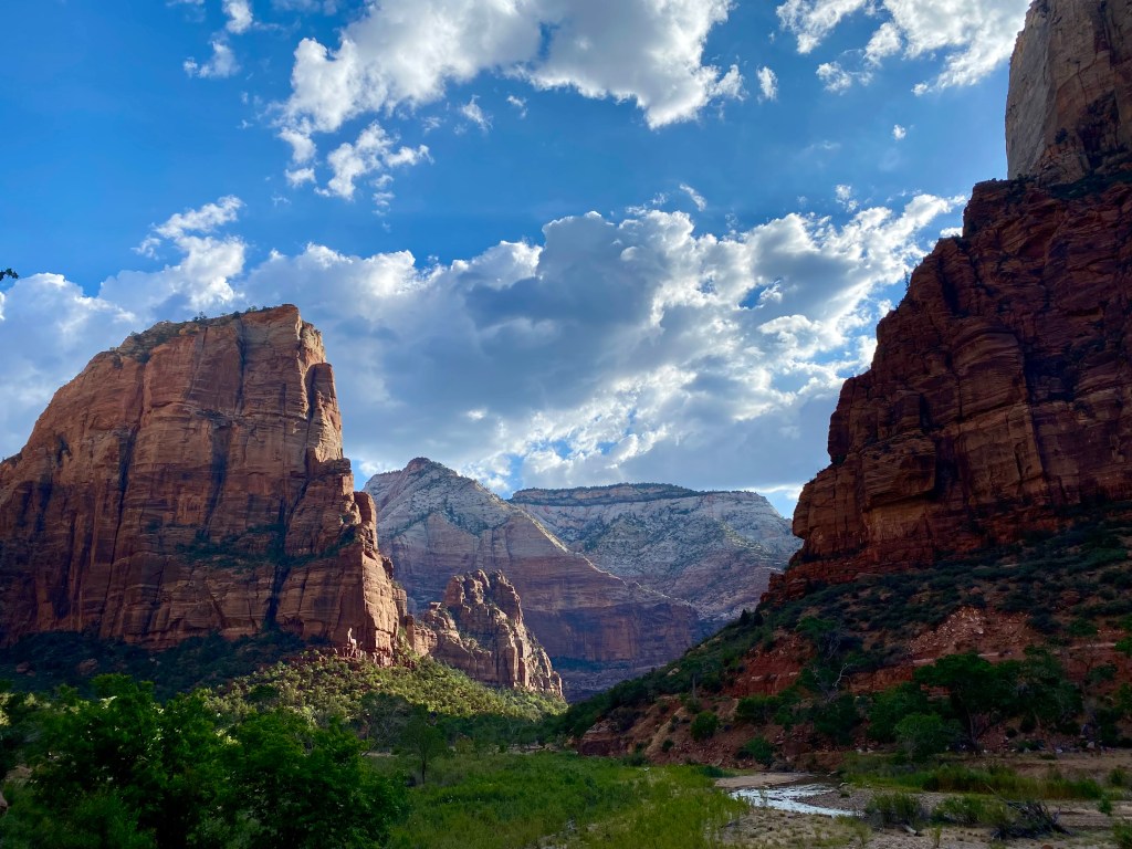
We awoke early the next morning to beat the crowds to The Narrows, a popular and majestic hike in the narrowest part of Zion Canyon. We first rented gear at an outfitter store near the entrance to the park, including waterproof shoes and trekking poles to help us make our way through the Virgin River which cuts through The Narrows. If you aren’t familiar with the geography of Zion National Park, the main part of the park is a deep canyon with 2,500-foot high sandstone cliffs (the tallest in the world!) that jut out from both sides as you make your way down the valley floor. At nearly all times, you are alongside the Virgin River, which carved the canyon and is still eroding it to this day.


Zion was declared a National Monument in 1909 and a National Park in 1919, and to the visitor it’s easy to see why! The word “Zion” means “touched by the divine”, and many early Mormon settlers saw the canyon this way after they journeyed through the barren desert only to find a paradise among landscapes to settle. Tall Cottonwood Trees alongside the river guide you down the main road to many of the hikes. Hikes can only be accessed through the park’s free shuttle service which mitigates automobile traffic on the narrow road through the canyon. On the way over to The Narrows on the park shuttle, we caught a glimpse of some of Zion’s bold and benign wildlife. First were some Common Ravens followed by a herd of Mule Deer and a very habituated, obese Rock Squirrel.

Driving along on the shuttle, the scenery took my breath away. Zion is by far the most gorgeous place I’ve ever been to in my life, and the first views I got of the greenish red-rock canyons illuminated with the golden dawn light were unforgettable. It was 8am by the time we were on the trail to our hike, and were ready to complete 10 miles of The Narrows.
The route we followed took about 6 hours to complete; after we got past the Disneyland-esque crowds in the first leg of the hike, it was like being in a whole different world. The canyon, whilst retaining its height, becomes so narrow in an area called Wall Street that you can almost touch both sides of it at once! The canyon walls, smoothed by millions of year of gushing water, flow in chiseled, wavelike shapes. Dappled sunlight filtered into many of the slenderest parts of the canyon, creating an almost eerie feeling as we sloshed through the clear waters of the Virgin River.
Using our trekking poles for balance amongst the slippery rocks of the waterway, we moved in a zigzag pattern through the river, attempting to avoid the deeper areas so we wouldn’t soak ourselves. (We failed, and eventually we decided to take a dip in a clear pool our our way back, which was really fun!) The dry desert air slowly warmed as the day progressed, which was pleasant as the river, which welled up from cold springs farther up the canyon, was something like 55 degrees Fahrenheit. My dad spotted a young Gopher Snake as it slithered through the chilly river toward dry land.


After reaching an area of the hike known as “Big Springs”, a waterfall that protrudes from the canyon walls and feeds the river and the main turn-back point for most hikers, we started the trudge back to the entrance. As we headed back, the crowds started becoming more apparent. We took a quick dip in an area of the river, a turquoise pool that was dammed by flood debris and provided a nice area to cool off.

Shortly after, we headed back to the shuttle, arriving back at the park entrance around 2:30. We ate (a rather underwhelming) lunch in the nearby town of Springdale and went back to our inn for a siesta. Afterward, we packed up our gear and readied ourselves for our next hiking destination: the remote Kolob Canyons, located in the northwest corner of Zion National Park and famed for having the same majesty of Zion Canyon without the crowds.
We embarked on the 5-mile round-trip Taylor Creek Overlook Trail, which follows a small, windy brook through Ponderosa Pine, Utah Juniper, Douglas Fir and Manzanita forest and is edged by vertical walls of solid, sunset-orange sandstone that rise 2,000 feet from the valley floor. The vegetation in the Kolob Canyons differs from Zion Canyon because of a rise in elevation; instead of cottonwood forest and desert shrub, the dominant plants are conifers.
Our hike was really beautiful, especially with the setting sun to our backs, and the lack of other people on the trail. Regarding wildlife, despite the more pristine terrain, we didn’t see too many animals while hiking, mostly birds and lizards. Alongside a ton of caw-ing Common Ravens, we saw Mountain Chickadees, a lone Wild Turkey, and a Woodhouse’s Scrub Jay. It was nearly dusk as we made our may back to the car, and after another pretty nasty meal we arrived at our inn.


Day 3 was another early start. We caught the shuttle toward Angel’s Landing, a famous hike that leads to the top of a 1,500-foot-high rock formation in the center of Zion Canyon. In some areas, the trail to the top of the peak is no more than three feet wide! Keep in mind that on both sides of these areas of the trail are thousand-foot sheer cliffs and that the only safety feature are some chain guardrails. Due to safety concerns regarding how crowded the trail gets, a lottery system was put in place earlier this year for hikers wishing to reach the summit. We unfortunately were too late to enter the lottery and therefore too late to hike to the top of Angel’s Landing.
However, the scenic viewpoint known as Scout Lookout, about 500 feet below the summit is open to all hikers and provides virtually the same panoramic view of Zion Canyon as Angel’s Landing summit. A series of switchbacks carved into the sandstone bring visitors up from the floor of the canyon to Scout Lookout. The spectacular morning on this day lit up the canyon in an aura of gold as we walked up from the shuttle stop toward the first switchbacks. From the trail we could see almost the entirety of Zion Canyon.
Lots of lively Uinta Chipmunks greeted us as we plodded up the track to the summit. High above were soaring Turkey Vultures. The hike was pretty easy for my dad and I, but we’re pretty fit in this regard. At Scout Lookout itself, we weren’t able to get a good view of the canyon so we journeyed up a nearby trail that stretched in the opposite direction of the trail to Angel’s Landing. The trail we followed let out at a flat rocky area with AMAZING views of virtually the whole canyon! It was truly an incredible sight!


Unfortunately, as we began hiking down the mountain, I had a really upset stomach. We had to cancel one of the hikes we were planning– Lower Emerald Pool. When the shuttle had dropped us off at the parking lot near the entrance, I needed a few hours to recover so we went back to our inn to check out and rest for a bit. By this time it was 2pm and we were ready to embark on one of our last Zion endeavours before driving two hours to Bryce Canyon National Park: biking the Pa’rus Trail all the way to the shuttle stop for The Narrows.
This spectacular biking trail is mainly flat until meeting up with the park’s main road. It snakes alongside the Virgin River and brings visitors through the lush floor of the canyon. The approximate biking distance from the Zion outfitter store located just outside the park (where bikes can be rented) to The Narrows trailhead is about 8 miles one-way. My dad and I did some pretty intense road biking in Hong Kong, up to 40 miles in a single outing, so we found the ride quite leisurely and fun. The views were outstanding– you really can’t get an idea of how majestic Zion Canyon is until you walk or bike through the middle of it!


After finishing our ride, we bought some groceries for our rental villa near Bryce Canyon, and drove up to and through the famed Zion-Mt. Carmel Highway Tunnel, once the world’s longest automobile tunnel. On our way out of the park, we stopped and hiked the Canyon Overlook Trail, which we didn’t enjoy due to harsh, late afternoon light and crowded overlooks. The drive from Zion to Bryce was quite pleasant, and the scenery was pretty awesome, especially as we drove through the impressive scenic drive of Red Canyon, Dixie National Forest. Our villa was located in the one-horse town of Cannonville, about 30 minutes away from the park. We settled in, had dinner and went to bed early so we’d be well-rested for an all-day hike in the morning.
We took our time getting ready the morning of Day 4. We arrived at Bryce Canyon National Park at around 10am and arrived shortly after at Bryce Point, start of the 22-mile Under the Rim Trail, a portion of which we’d be hiking. The geography of Bryce Canyon is astoundingly different from Zion, and from most other places on Earth. It isn’t a canyon at all– instead it’s a natural geologic amphitheater that stretches down half a mile, starting at a high plateau located around 8,000 feet above sea level.
Bryce Canyon is one of the highest points of the Grand Staircase, a series of colorful sedimentary cliffs descending from this area of Southern Utah down to the bottom of the Grand Canyon. Bryce’s most unique natural feature are its hoodoos– tall irregular rock columns that have been eroded from the region’s limestone over millions of years. Bryce has the highest concentration of hoodoos anywhere in the world, and some of the formations are truly amazing. The park is far more forested than Zion, consisting mainly of Ponderosa Pine forest intermingled with pink, white and orange hoodoos.
The view from Bryce Point, located on the top of the Bryce Amphitheater at 8,300 feet above sea level, gives visitors a vista of endless rows of hoodoos and of over 100 miles of the Southern Utah landscape. Bryce Point, while not quite as spectacular as Zion, was still an astoundingly unique look at the rock formations that make this area of America so special.


Our hike took an agonising 8 hours to complete and covered more than 15 miles of Bryce’s beautiful alien landscape. The altitude had little effect on my dad and I, with the notable exception of the 4 miles of incline we had to hike up on our way back…. the dry air sapped all of our moisture so our water supplies were depleted within the first few hours. A note to whoever decides to hike Bryce for the first time: everything is downhill from the trailhead until you turn back– its all incline from then on, coat yourself in sunscreen to protect against the harsh sun up there, and whatever you think is a sufficient amount of water for your hike, double it! As for wildlife, we saw White-Throated Swifts, Pinyon Jays, Clark’s Nutcracker and Townsend’s Solitare for birds, and Uinta Chipmunks for mammals. Overall the hike was fabulous and a nearby thunderstorm kept most of the harsh, high desert sun off of us for the majority of the time we were on the trail. We trekked from Bryce point down about 1,500 feet to a dry riverbed at the base of some hoodoos in the middle of a lush Ponderosa forest. We ate lunch in an area that looked like the backdrop to an old western movie!


By the time we arrived at the parking lot, we were both exhausted and opted to head straight back to our villa versus doing a scenic drive around the park. On our way out, we stopped at the local colony of Utah Prairie Dogs, an endangered (and very cute) species of rodent endemic to the high desert of Southern Utah. The colony at Bryce was pretty active, and we saw several individuals within a few minutes. It’s always great to see endangered animals in the wild, and I thoroughly enjoyed our visit to the prairie dog colony!

We both slept hard, and awoke the next morning to meet up with my Boy Scout Troop for a hike around one of Bryce’s easier trails before departing to camp. At the Bryce Canyon visitor center, I reunited with my best friend since 6th grade, Lincoln, whom I hadn’t seen in years because of his family’s reassignment to Mongolia. It was great to catch up with everyone in my troop and shortly after starting the hike, us boys started having our own conversations and began doing unintelligent things, like sniffing aromatic Ponderosa trees and climbing up boulders. The trail we did was the 3-mile round-trip Navajo Loop, which brings hikers right up against the hoodoos, and makes for some seriously awesome viewpoints. It was such a great hike!


As we came close to ending our hike, a nearby monsoon thunderstorm had caught up to us, dumping huge quantities of rain on the plateau where our hike started. The lightning streaked by extremely close as we reached the parking lot. I dove into Lincoln’s car and my dad into our rental, and we set off to the camp after a quick goodbye, my dad heading back to Las Vegas to catch a plane back to New York.
Camp was a blast, but in this blog post I felt like talking about the wonderful trip I had with my dad before camp. A note that the lists of birds and mammals I recorded below include both what I saw with my dad and at camp. It was an exceptionally memorable experience and I feel very grateful and privileged that my dad took me to see a new and amazing part of our great nation. I experienced firsthand from this trip that our National Parks preserve the greatest pieces of America for the people and that they are truly a beacon of American ideals. I most assuredly want to visit all 63 of them someday!
Thanks for reading as always, and stay tuned for more posts as my family moves to Singapore in a few weeks!
Mammal Species Recorded: (7 total, all lifers!)
Uinta Chipmunk (Lifer)
Rock Squirrel (Lifer)
Yellow-Bellied Marmot (Lifer)
Utah Prairie Dog (Lifer)
Mule Deer (Lifer)
Golden-Mantled Ground Squirrel (Lifer)
Desert Cottontail (Lifer)
Bird Species Recorded: (21 total, including 12 lifers)
Black-Billed Magpie (Lifer)
Mountain Bluebird (Lifer)
Western Tanager (Lifer)
Common Raven
Turkey Vulture
California Gull (Lifer)
Clark’s Nutcracker (Lifer)
Red-Tailed Hawk
Chipping Sparrow
American Robin
White-Throated Swift (Lifer)
Mountain Chickadee (Lifer)
Wild Turkey
House Finch
Steller’s Jay (Lifer)
Woodhouse’s Scrub Jay (Lifer)
Pinyon Jay (Lifer)
Mourning Dove
Dusky Flycatcher (Lifer)
Townsend’s Solitaire (Lifer)
Hairy Woodpecker

Leave a comment